


 32 / 116

Oktober 2017
30
Salt-affected soils and waterlogging
on irrigation schemes
A
t the very first South African Irrigation Congress held in
1909, much concern was expressed at the extent of salt-
affected soils and the sediment content of water supplies
(Kanthach, 1909). At the National Irrigation Symposium
82 years later, Scotney and Van der Merwe (1991) had the same
concerns and said that the long-term viability of soil and water re-
sources is in jeopardy. Major threats to these resources result from,
among others, salinity, sodicity and waterlogging.
A review of about 3 000 soil irrigation reports at the ARC-
Soil, Climate and Water, revealed that soils free of limitations
for sustainable irrigation are limited in extent in South Africa. How-
ever, it appears that waterlogging, salinity and sodicity affects only
10% to 18% of the area under regular irrigation in South Africa.
This is much lower than experienced in many countries, because of
the strict emphasis placed on the potential for waterlogging, salinity
and sodicity and its prevention in the selection criteria for irrigated
soils in South Africa in the past. Another advantage is the generally
good water quality that has historically been available for irrigation
in South Africa.
Currently the salinity and sodicity of South African waters are on
the increase due to mining, urban, industrial and agricultural devel-
opments and the re-use of water resources. Irrigated agriculture is
not only at the receiving end of water quality deterioration, but also
a contributor to water quality deterioration experienced in many
rivers. The use of this water poses a future threat for soils on South
African irrigation schemes where leaching is limited.
It is evident from information available that the degree of degrada-
tion varies considerably between irrigation schemes and also over
time within the same irrigation scheme in South Africa. An increase
in salinity and sodicity normally coincide with hydrologically dry
years with below-average runoff and an increase in waterlogging
during hydrologically wet years.
Satellite images to quantify and identify
salt-affected soils and waterlogging
National monitoring of waterlogging and salt accumulation are a
high priority, but currently no verified methodology is available to
undertake this task. A recently completed Water Research Com-
mission project by researchers from the ARC-soil, Climate and
Water and Stellenbosch University sought to determine the po-
tential of various data sources and techniques for monitoring wa-
terlogging and salt accumulation and to quantify the current level
of waterlogging and salt accumulation and monitor changes over
time at the appropriate scale on irrigation schemes in South Africa
(Nell
et al
., 2015).
Remote sensing is the practice of deriving information about the
earth’s land and water surfaces using images acquired from an over-
head perspective, by employing electromagnetic radiation in one
or more regions of the electromagnetic spectrum, reflected or emit-
ted from the earth’s surface.
The challenge with using remote sensing for identifying and de-
lineating waterlogged and salt-affected areas is that they are local
manifestations and can only be differentiated from unaffected areas
by taking its context (surrounding area) into consideration. For in-
stance, an affected area within a wheat field will have very different
spectral properties to an affected area in a vineyard, while the latter
will have a very different spectral response compared to an affected
area within a bare/fallow field.
The occurrence of salt accumulation and waterlogging in generally
mall patches in South African irrigation schemes poses additional
challenges.
FOCUS
Irrigation
Special
DR PIET NELL,
ARC-Soil, Climate and Water
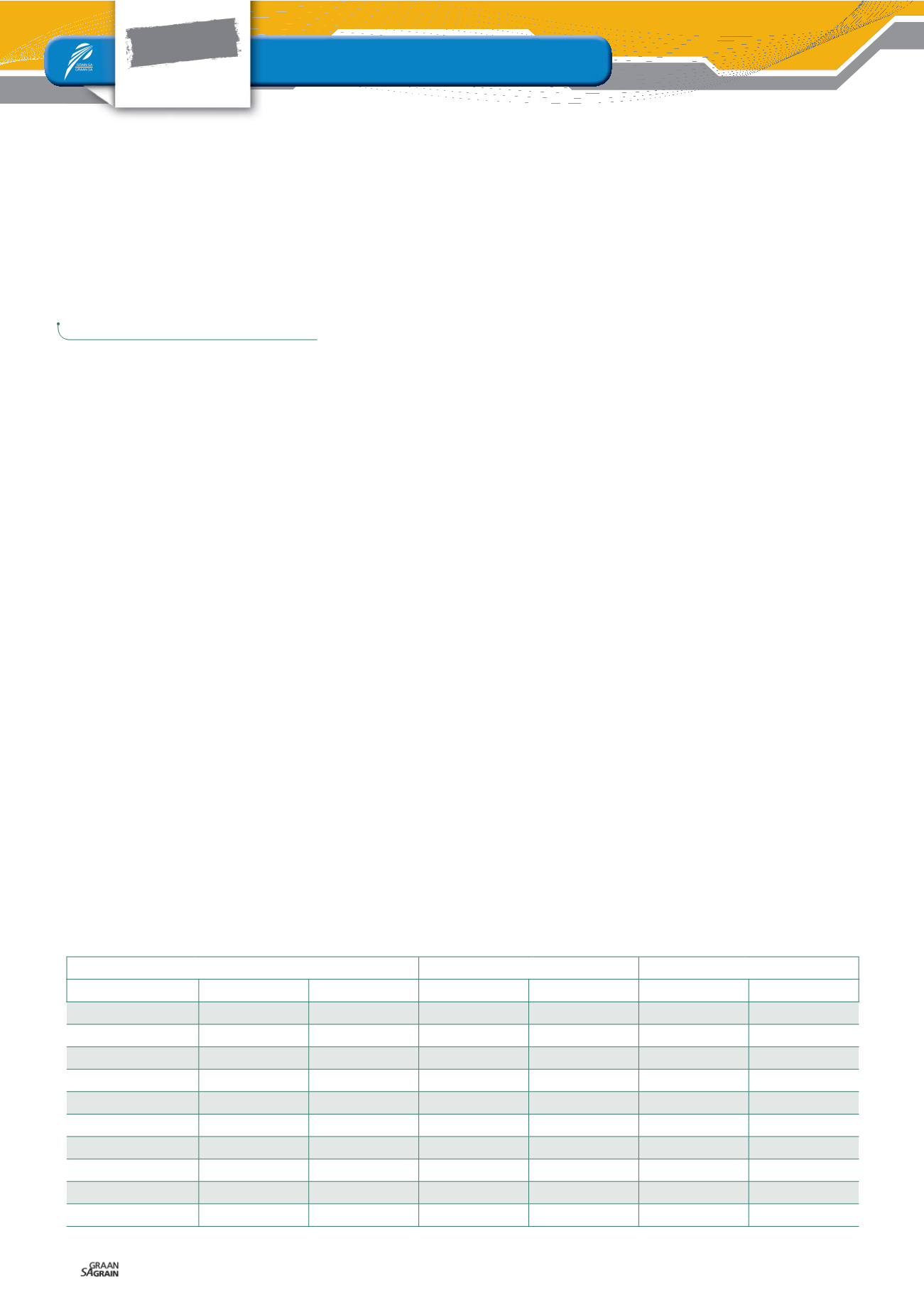
STUDY AREA
AFFECTED
ADJUSTED
NAME
HA
HA*
HA
%
HA
%
Vaalharts
26 434
27 033
414,7
1,57
848,9
3,14
Loskop
38 831
40 867
887,1
2,28
2 344,7
5,74
Makhathini
4 312
4 624
138,5
3,21
361,1
7,81
Olifants River
11 284
11 911
224,6
1,99
664,9
5,58
Tugela River
27 384
28 244
1 477,3
5,39
2 102,8
7,44
Breede River
29 129
30 188
1 396,8
4,80
2 215,3
7,34
Sundays River
18 608
18 832
528,2
2,84
740,5
3,93
Limpopo River
8 681
8 805
468,1
5,39
564,0
6,40
Douglas
22 748
23 445
1 483,3
6,52
2 124,0
9,06
MEAN
20 823
21 550
779,8
3,78
1 329,6
6,27
* Area adjusted by adding abandoned fields
TABLE 1: SUMMARY OF THE AREAS AFFECTED BY SALT ACCUMULATION AND WATERLOGGING.